↓
 

San Antonio Land Surveying

Local Land Surveyors in San Antonio, TX

San Antonio Land Surveying
  • Home
  • ALTA Survey
  • Boundary Surveying
  • Construction Survey
  • Drone LiDAR Mapping
  • Elevation Certificate
  • Land Surveying
  • Topographic Survey
  • About Us
  • Blog
  • Contact Us
Home - Page 3 << 1 2 3 4 5 … 11 12 >>

Post navigation

← Older posts
Newer posts →

Warehouse Buyer’s LiDAR Mapping Checklist: Creeks, Culverts, and Truck-Access Grades

San Antonio Land Surveying Posted on August 26, 2026 by SanAntonioSurveyorAugust 20, 2026
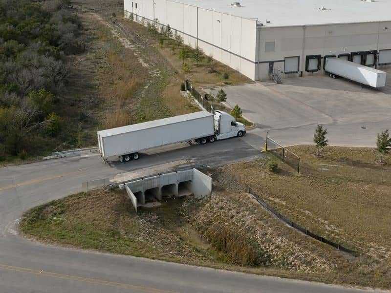
LiDAR Mapping view of warehouse truck access near a drainage culvert in San Antonio Texas

A warehouse deal lives or dies on access. The building matters, but a truck that can’t reach the dock turns a good site into a bad one. That’s why smart buyers run a LiDAR mapping checklist before they fall for a floor plan. Trucks are long, heavy, and picky about grade, so the ground around a warehouse carries as much weight as the walls. Reading that ground early keeps a buyer from paying for problems the seller never mentioned. A checklist keeps the review honest, since it forces a buyer to look at each part of the site rather than falling for a shiny listing photo.

Warehouse Site Selection Begins With the Truck Route

The first question isn’t where the building sits. It’s how a full trailer gets in, turns, backs to a dock, and leaves without trouble. Delivery entrances, emergency routes, and internal circulation all shape whether a site works for freight.

A buyer who studies the truck route first sees the site the way a driver does. Tight corners, steep entrances, and awkward approaches show up fast. Once the route makes sense, the building location becomes a lot easier to judge, because the hard part of warehouse access is already sorted.

LiDAR helps here by showing the grade along every path a truck might take. A route that looks fine on a flat map can climb or dip in ways that slow a loaded trailer. When the elevation data reveals those changes early, a buyer can picture real trucks moving through the site instead of trusting a hopeful sketch.

How Can Culverts Affect Trailer Turning and Driveway Design?

Culverts and roadside ditches sit right where a driveway usually wants to go. A culvert that’s too small, too shallow, or badly placed can force a driveway to shift, which then squeezes the space a trailer needs to turn. Small drainage crossings create the same headache near the property line.

LiDAR shows the grade around these crossings clearly, so a buyer can spot a pinch point before design begins. When the elevation data reveals a steep ditch or a low culvert at the entrance, the team knows access improvements may cost real money. Catching that early beats finding it after closing.

The fix for a bad crossing is rarely cheap. Widening a culvert, regrading a ditch, or rebuilding an entrance all add to the budget, and each one eats into the money a buyer sets aside for the building itself. So a crossing that limits trailer movement isn’t just an access issue, it’s a cost hiding in plain sight until the mapping brings it forward.

Loading-Dock and Truck-Court Grade Conditions

Docks are unforgiving about slopes. A truck court that pitches the wrong way can trap water, strain equipment, and make backing tricky for drivers. Ramps and approach areas need the right grade so trailers connect smoothly and safely.

Accurate elevations around docks, ramps, and courts let a buyer compare properties on more than square footage. One site may sit almost level and need little work, while another hides a grade problem that adds cost. With mapped data in hand, that difference stops being a mystery and becomes a number the team can plan around.

Drivers feel these grades every day, even when a buyer never notices them. A court that slopes toward the building sends water at the docks, and a ramp that’s too steep wears on both trucks and the pavement. When the mapping flags those conditions, a buyer can weigh the repair cost against the rest of the deal.

Creek Crossings and Low-Point Access Constraints

Water near a site shapes access in ways a photo never shows. A creek, a low-water crossing, or a drainage channel can block one approach entirely or flood it after heavy rain. Low points along an access road can hold water long enough to stop a delivery.

LiDAR captures those terrain conditions so a buyer sees the constraint before committing. If the only clear route crosses a low channel, that’s worth knowing while there’s still room to walk away. Mapping turns a vague worry into a clear picture of where access holds up and where it doesn’t.

A second route sometimes solves the problem, and sometimes it doesn’t exist. The elevation data helps a buyer test that question by showing which paths stay high and dry. When every option crosses a low point, the site’s access risk becomes part of the price, not a detail to sort out later.

A LiDAR Mapping Comparison Matrix for Warehouse Buyers

Once several sites are on the table, a matrix keeps the choice honest. Instead of trusting memory, a buyer lines up the same factors for each property and compares them side by side. LiDAR data feeds that comparison with real ground measurements.

A useful matrix compares each site across a few key points:

  • Usable acreage after low areas and setbacks are removed
  • Grade changes across the truck court, docks, and drive lanes
  • Culvert locations and how they affect driveway placement
  • Access constraints near creeks, ditches, and low crossings
  • Potential grading needs and the rough effort each site demands

When these rows are filled with measured values, the strongest site tends to stand out on its own. That’s a far better way to choose than reacting to whichever listing had the nicest photos.
Posted in LiDAR Mapping | Tagged LiDAR mapping

LiDAR Mapping in San Antonio: Can It Locate Buildable Ground Above a Flash-Flood Drainage Path?

San Antonio Land Surveying Posted on August 24, 2026 by SanAntonioSurveyorAugust 20, 2026
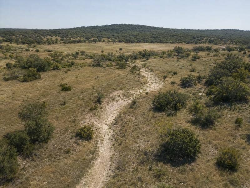
LiDAR Mapping showing a natural drainage path and potential building ground on undeveloped land in San Antonio Texas

Buying raw land looks simple until the ground fights back. A gentle-looking field can hide a drainage path that carries fast water after a storm. That’s where LiDAR mapping earns its keep, because it reads the shape of the ground in fine detail before anyone spends money on a design. When runoff moves quickly across a site, small dips and low spots decide a lot. Getting that picture early can save a buyer from a costly surprise later.

Flash-Flood Terrain Risks on Potential Development Land

Flat-looking land is rarely flat. A slope of even a foot or two can send water toward one corner of a property during heavy rain. Shallow swales, small depressions, and old drainage paths all steer that flow, and they often go unnoticed on a quick walk.

These features matter early, before a layout is drawn. If a building pad sits in a natural low point, water finds it every time a storm rolls through. A buyer who spots these patterns up front can shift plans, ask better questions, and avoid land that carries hidden water risk. When fast runoff is part of the picture, that early read becomes even more useful.

How Can LiDAR Mapping Reveal Hidden Overland Flow Routes?

LiDAR uses laser pulses to measure ground height across a whole site, so it captures far more detail than a person can see while standing on the property. Once that data is processed, subtle terrain shows up clearly, and flow routes that hide under grass or brush finally become visible.

Detailed elevation data can point out several things that shape early site decisions:

  • Low areas where water pools or slows down after a storm
  • Natural swales that carry runoff across the property
  • Old drainage paths left behind by past grading or erosion
  • Grade breaks where the slope changes and flow direction shifts
  • Ridges that split runoff and send it toward different edges

Because these patterns come from measured heights, they give a project team something solid to study instead of a guess. That way, a review can start with real ground shape rather than a hunch made from a single visit.

Building-Pad Screening With Accurate Surface Elevations

Once the surface is mapped, a team can compare possible building-pad areas against the grades around them. A pad that sits slightly higher than nearby ground behaves very differently from one that sits low. Accurate elevations make that comparison honest and repeatable.

Survey data helps the team screen options, yet it does not settle the question of buildability on its own. Engineers run the drainage math, and local officials apply the rules that decide what a site can hold. So LiDAR narrows the field and flags concerns, while the final call stays with the people who carry that responsibility.

Existing Grading and Natural Drainage Patterns

Not every slope on a property is natural. Past owners may have added fill, scraped the surface, or built up pads that changed how water moves. Those changes can hide the original drainage pattern and fool a buyer who only sees today’s shape.

Because of that, field verification still has a place. LiDAR shows the current surface, but a crew on the ground can confirm what caused it and whether the soil beneath is stable. When old site work is likely, that mix of mapped data and field checks gives a clearer answer than either one alone.

Survey Findings That Require Additional Professional Review

Some results point straight toward more review. If mapping shows water crossing a proposed pad, or a low area near a planned entrance, that finding belongs in the hands of a civil engineer or floodplain manager. A field survey crew may also need to verify the spot before design moves forward.

Sharing data early keeps everyone working from the same picture. It also helps a buyer ask the right questions before writing a large check. Good mapping starts the conversation, and the right professionals finish it.

Frequently Asked Questions

Can LiDAR Mapping confirm a FEMA flood zone? 

LiDAR does not set or confirm a FEMA flood zone on its own. Flood zones come from official maps and studies managed through federal and local channels. The elevation data can support a review, but a floodplain manager or engineer interprets how a property relates to a mapped zone. Always treat the mapping as input, not a final flood determination.

Does LiDAR Mapping replace an Elevation Certificate? 

No, these serve different purposes. An Elevation Certificate is a specific document that records set elevations for a structure, often for insurance or permitting. LiDAR gives a broad surface model across a site, which is useful for planning but not the same as a certified form. When a certificate is required, a licensed surveyor prepares it separately.

Can LiDAR locate buried drainage pipes? 

LiDAR reads the ground surface, so it cannot see pipes buried below it. It can show surface clues, like a low channel or an outfall area, that hint at drainage nearby. To locate buried lines, a team relies on utility records, field locating, and sometimes exposure by hand. The mapping points to where those checks make sense.

Will LiDAR Mapping work on a wooded property?

Yes, though results depend on how thick the canopy is. Some laser returns reach the ground through gaps in the leaves, which lets a crew build a ground surface under trees. Dense evergreen cover reduces those returns and lowers detail in shaded areas. On heavy woods, field survey often fills the gaps the laser misses.

Who decides whether land is buildable? 

Buildability is a shared decision, not a survey result. Engineers study drainage, soils, and site limits, while local officials apply zoning and permitting rules. The surveyor supplies the ground data that supports those reviews. So mapping informs the choice, but the responsible professionals and agencies make the final call.

Posted in LiDAR Mapping | Tagged LiDAR mapping

Property Survey Before a Backyard Addition Pushes Toward the Setback

San Antonio Land Surveying Posted on August 19, 2026 by SanAntonioSurveyorAugust 15, 2026
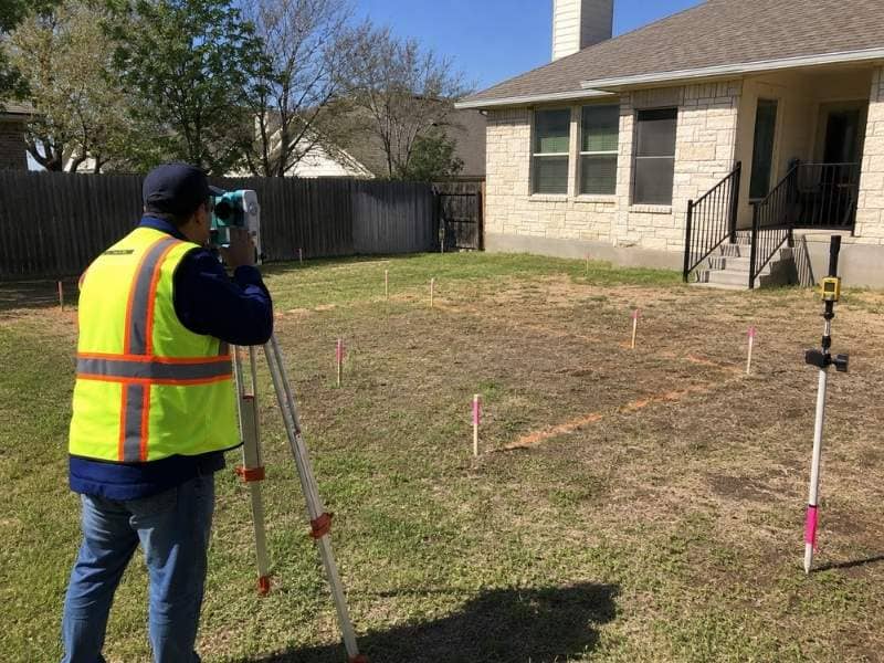
Property Survey for a backyard home addition near a setback in San Antonio Texas

Adding onto your home gives you more space. It also brings you closer to property lines and setback limits. If you build too close, the city may reject your permit. You may have to tear down completed work. A property survey shows exactly where your boundaries lie. It tells you how close you may safely build before work begins.

Know the Boundary Before Measuring the Remaining Yard

You cannot guess where the line sits. Fences, trees, or old markers may be off by several feet. If you measure from those references, your design will be wrong. A surveyor finds the true property corners and marks them clearly. You then measure setbacks from those legal points, not from guesses.

Setback rules tell you how far your addition must stay from each boundary. Those distances apply to the property line, not to whatever sits on it today. Start with the survey. Then design within the allowed space. That order protects your permit and your investment.

Existing Walls and Fences Are Reference Features, Not Legal Answers

Fences and walls show where someone thought the line belonged. They do not prove the boundary. A fence may sit a foot inside your land or a foot across it. Using it as your reference can lead to expensive mistakes.

The survey compares fences and walls against true lines. You learn whether they are correctly placed or not. If the fence is wrong, you still build from the surveyed line. That way your new addition is legal even if the old fence is not.

Locate the House Accurately Before Extending It

Your existing home may not sit exactly where the old drawings show. It may have been built slightly off line decades ago. If you extend based on the old plan, you may build too close to the boundary. A survey measures the house walls against property lines. You learn exactly where the building sits today.

That measurement becomes your starting point. You see how much space remains toward each line. Your architect then designs the addition to fit within allowed distances. You avoid discovering too late that the extended house violates setback rules.

Let the Designer Apply the Applicable Setback Requirements

Surveyors mark lines and distances. They do not decide zoning or setback rules. That responsibility belongs to your designer, architect, or planning department. They take the surveyed boundaries and apply the rules that apply to your property.

The survey gives them the facts they need. They calculate allowed building areas and tell you exactly how large and how close your addition may be. Separating these roles keeps the process clear. You get accurate measurements and reliable design guidance from the right people.

Use Construction Layout When the Addition Reaches the Field

Once design is approved, the surveyor can mark the actual corners on the ground. They transfer the approved plan onto your lot using stakes or marks. Builders then follow those official marks instead of guessing or using fences.

This step ensures the foundation sits exactly where it was designed. It also shows inspectors that you built within surveyed boundaries. If questions arise later, you have clear proof that the work was placed correctly.

Posted in Property Survey | Tagged Property Survey

Post navigation

← Older posts
Newer posts →
Get Quote Button
© Boxer Survey USA
San Antonio Land Surveying

San Antonio, Texas
Phone: (210) 405-7250

Privacy Policy | Terms of Use

Web Development and SEO by:
AuburnBusiness.com, LLC


Privacy Policy | Terms of Use

The owner of this website, Boxer Survey USA, provides coordination of professional land surveying and engineering services in all 50 states. The professional surveying and engineering services provided to you will be conducted by fully licensed professionals in your state.

↑